Creation of scheme of base stations on object in a separate window |


|
|
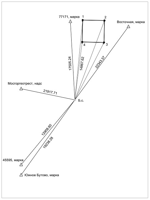
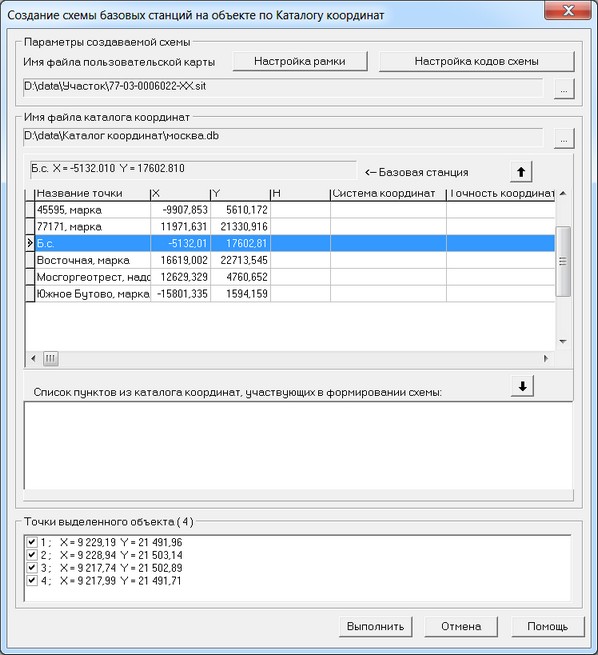
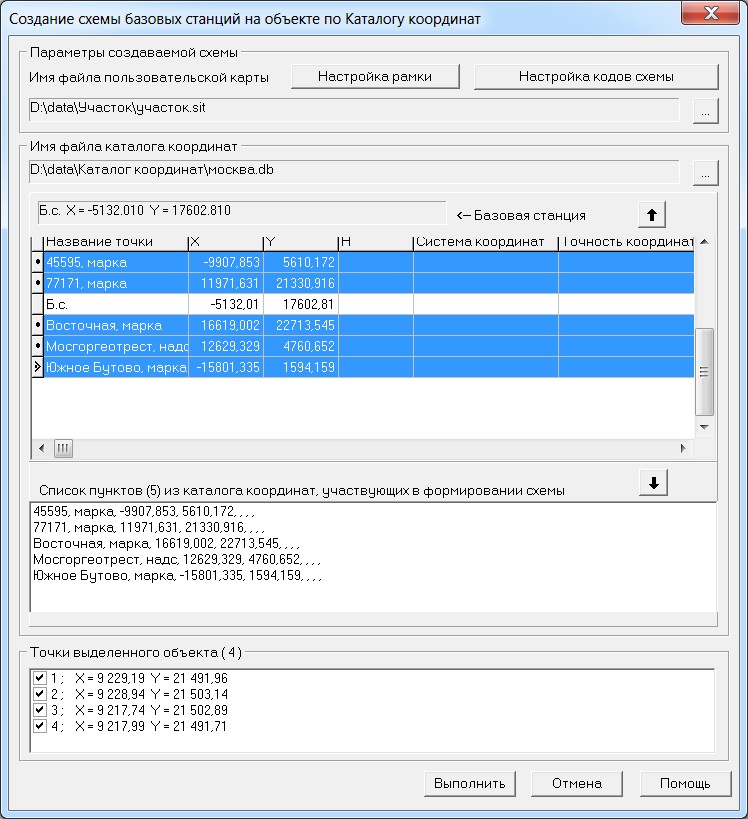
1. Select on the map the analysed object. After mode start on a map it is necessary to select the object being studied, for example, a land plot. 2. Enter a filename of the created map. After a choice of analysed object, the dialogue Creation of scheme of base stations on object by the catalogue of coordinates will start. In dialog Creation of scheme of base stations on object by the catalogue of coordinates in group Parameters of the scheme you must specify the file name of a created map (the button "..."). 3. Specify the codes of objects created on the output map. In dialog Creation of scheme of base stations on object by the catalogue of coordinates in the Parameters of the scheme press the button Parameters. Customize the codes of objects created on the output map in the form Parameters of scheme of location of the base and defined stations. 4. Set up the parameters of frame of the printed sheet frame of a printed sheet, created on the output map. In dialog Creation of scheme of base stations on object by the catalogue of coordinates in the group Parameters of the scheme press the button Set up the frame. Customize the parameters of the frame of printed sheet created on the output map, in the form Parameters of a printed sheet's frame. 5. Select the filename of the catalogue of coordinates containing records with coordinates of base station and GGS points. In dialog Creation of scheme of base stations on object by the catalogue of coordinates in group Name of the file of the catalogue of coordinates you must specify the file of the coordinates catalogue (the button "..."). Contents of a file of the coordinates catalogue are displayed in the table located under the filename of the catalogue of coordinates. 6. Specify the base station from the catalogue of coordinates. In the dialog Creation of scheme of base stations on object by the catalogue of coordinates in group Name of the file of the catalogue of coordinates in the table of the catalogue of coordinates you must specify the record with base station and press the button UP.
7. Specify the used GGS points from the catalogue of coordinates. In dialogue Creation of scheme of base stations on object by the catalogue of coordinates in group Name of the file of the catalogue of coordinates in the table of the catalogue of co-ordinates you must specify the records with points of the state geodetic network and press the button DOWN. Selected records with points of geodetic network are transferred into The list of items from the catalog of coordinates. Record with the base station should not get into The list of items from the catalog of coordinates, the program will check up and if necessary will display the message. For selection of several records, use the keyboard shortcut: Ctrl+Left mouse button.
8. Specify used points of analysed object (Points of initialization). Initialization points (standing point) are the point objects selected on a map, or the points of the contour chosen on a map of the square or closed linear object. Initialization points in dialogue Creation of scheme of base stations on object by the catalogue of coordinates are displayed in the list Object points (number of points). Specify in the list those points which should be on the scheme. 9. Start scheme creation. After customization of all parameters in dialog Creation of scheme of base stations on object by the catalogue of coordinates, press the Execute button. There is a scheme creation on a new user map which opens in a new window (document). |