View entry the objects |


|
|
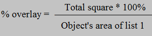
Result of the mode operation are the calculated values of the areas of objects entry of the list 2 (analyzed objects) onto objects of the list 1 (objects of overlay). The program determines the multiple entries of objects of list 2 into input objects of the list 1 and calculates the area of each entry in absolute units, and as a percentage of the object of overlay. To start calculations, you must select the lists of objects in the drop-down menus and click the "Calculate" button. Different lists should be selected. The drop-down lists "Semantics 1" and "Semantics 2" are filled with the semantics of the first object of the corresponding list. The first object is the first map object that has the smallest number in the list of maps. If the semantics "Name" (code 9) is not found among the semantics, it is forcibly written into the list. The results of the calculation of multiple overlay will be shown in two tables. The first table shows the list of objects of the list 1. The fields of the table contain the following information: - “Object from the List 1” - the value of semantics chosen in the "Semantics 1" drop-down list; - " Square" - the area of object of the list 1; - " Total square" - the area of crossing with all objects from the list 2; - “% overlay” - a part of object of the list 1 in percentage which is imposed on all objects from the list 2. It is calculated by the formula:
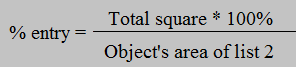
The second table is linked to the first table, and changes its contents when moving through the rows of the first table. It contains the list of objects from the list 2 that have crossing with the object selected in the first table. Table fields contain the following information: - “Object from the List 1” - the semantics value from the "Semantics 1" drop-down list selected in the first object table from list 1; - “Object from the List 2” - the value of semantics from the drop-down list “Semantics 2” of object from the list 2; - "Square" - the area of object from the list 2; - "Total square" - the area of crossing of object from the list 2 with the object chosen in the first table from the list 1; - “% entry” - a part of object 2 in percentage which is included into object of list 1, which is chosen in the first table. It is calculated by the formula
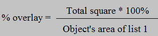
- “% overlay” - a part of object of the list 1 in percentage which is imposed on objects from the list 2. It is calculated by the formula:
Tag “Clarify area” carries out information function and is not available for change, it duplicates the value of the tag “Precise square and length” from the "Options" section of the main menu of the program. If the "Trace" check-box is used, while moving through the first table, the map will be positioned on the object selected in the table, and this object will be highlighted on the map. The "All list 1 objects" check box controls the filling of the first table. If it is set, even those objects of list 1 that have no crossing with any object from list 2 will be added to the table.
|