Numbering of objects, in rows |


|
|
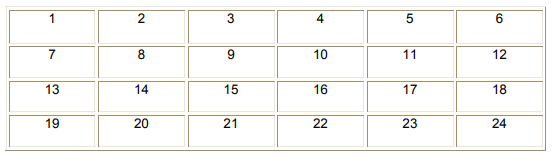
The "Numbering of objects, in rows" mode provides the formation of semantics containing the serial number of the object in accordance with its location on the map. Numbering is carried out in a direction from west to east, in rows from north to south. This procedure complies with the adopted rules for the numbering of forest quarters and can be used in the designing and inventory of forests.
To facilitate forest accounting, performing taxation and daily production work (allotment of cutting areas, main cutting, forest thinning, forestry, fire prevention, etc.), the forestry area is divided into smaller parts, which are usually called quarters. Depending on a detail of inventory works the area of quarter makes up from 25 to 3000 hectares. In shape they can be square, rectangular and of irregular configuration. The borders of the quarters are usually the cut-through glades. When drawing up the project of quarter network, as the quarter glades (borders) you can use the following: trunk lines of transport, permanent roads (timber-carrying, forestry and fire), fire breaks, routes of power lines and gas pipelines, rivers and other natural objects. With the arrangement of flat forests, a rectangular quarter network is designed with the laying of glades from north to south and from east to west relative to the true meridian. Within each forestry, the quarters are numbered in rows from left to right and from top to bottom (being oriented to the north). In accordance with the Decree of the Government of the Russian Federation of November 19, 2014 N 2320-r, the location of the forest site (forest stands) is given in various information systems and forest management documents indicating the subject of the Russian Federation, municipal district, forestry (forest park), local forestry, natural boundary (if available), forest quarter. Taking into account the fact that the numbering of districts is preserved only within one forestry (forest management) in order to perform the continuous numbering of forest districts within the boundaries of the local forestry, it is necessary to select objects on the map that characterize the forest quarters that are part of one local forestry and press the button of the mode «Numbering of objects, in rows».
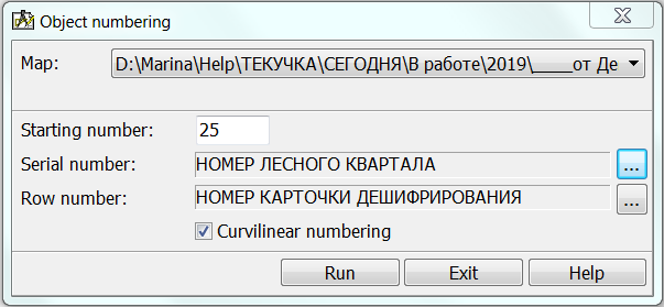
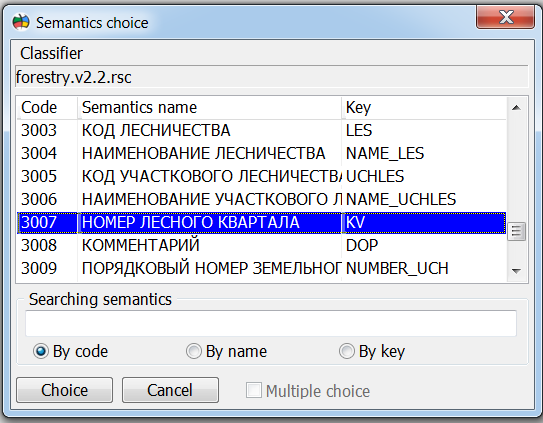
In dialog «Numbering of objects» you must choose semantics for serial number of quarter and for number of row. Necessary objects and semantics are contained in the digital classifier forestry.v2.rsc.
Algorithm of continuous numbering of objects is based on building the rows of quarters. The rows combine adjacent objects that are close to each other. As a base direction of building the rows, the direction «from west on east» is used. The program finds the most northwest object and further, consistently, attaches to this row the adjacent «east» objects that are close to a base direction. Upon reaching the "end" of the row, a search and building a new row is performed. For a network of quarters having the orientation of objects close to the direction «from west to east», and also having the same geometric shapes (all objects are close to squares, or all objects are the identical rectangles), the algorithm of numbering works without error. However, in some cases, the algorithm of continuous numbering may incorrectly form a serial number. The source of inaccuracies is the large deviation of quarter glades from the direction «from west to east», a sharp change in direction, or a significant measurement of the geometry and area of the quarters. To eliminate errors, it is recommended to select objects with homogeneous groups and call the mode several times. At the same time, in the element «Starting number» you can set a value that is a continuation of the numbering of the previous group. The territory of each forest quarter is divided into primary forestry accounting units - forest taxation units. Taxation unit is a limited forest area, relatively homogeneous in terms of quality and quantity of vegetation growing on it. The mode «Numbering of objects, in numbers» can be used for numbering forest taxation units. At the same time, you can use the property «Curvilinear numbering», which allows you to change the direction of numbering of objects of the even rows onto the direction of «from west to east».
|