Print project surveying the land |


|
|
The draft of subdivision is formed according to requirements to the project of the surveying approved by the order of the Ministry of Economic Development of the Russian Federation № 388 of August 3, 2011 The project of a survey consists of textual and graphic parts which are divided onto sections. The project of a survey defines the sizes and a location of borders of the land or the lands which can be apportioned on account of a land share or land shares (hereinafter - formed land). Within the limits of one document the data are filled about all the land formed as a result of drafting, in addition, data on all amended land are inserted into the same document. In the program the procedure «Project of land subdivision» is intended for the automated filling the sections of the project of a survey. For correct formation of the document «Project subdivision… » it is necessary: to prepare a map, select on a map all formed and amended land, call the mode «Print Draft Land surveying», specify in dialog of a mode the necessary parameters and click «Execute» button. Process of forming the project of a survey includes the following technological stages: - mapping objects of land-management; - drafting borders of formed land; - preparation of images for a graphic part; - input of attributive data on objects of land management: formed both the amended ground areas and their parts; - automated filling the sections of the technical plan. Mapping objects of land-management includes drawing all initial ground areas, parts of the initial ground areas and characteristic points of borders of the initial ground areas and their parts. In semantics of the initial land the CADASTRAL NUMBER of the land should be necessarily filled. If the initial land (plot or ground area (GA)) represents a uniform land tenure (ULT) or the multiplanimetric land, the semantics CADASTRAL NUMBER should be necessarily filled for each contour. For each contour of uniform land tenure the semantics ACCOUNT PART NUMBER should be filled. It is recommended to fill semantics ACCOUNT PART NUMBER and for all contours of multiplanimetric land. Designing borders of formed lands includes allocation of contours from structure of uniform land tenure or multiplanimetric land by full or partial withdrawal of a contour of the initial land. For completely withdrawn contour it is necessary to change simply type of object onto FORMED LAND. For partially withdrawn contour it is necessary first to divide the object into fragments, then and for withdrawn fragments (new objects of a map) to change type onto FORMED LAND. After withdrawal of contours it is necessary to destroy the existing set of objects describing initial uniform land tenure or multiplanimetric land and to generate them in the changed kind. For this purpose, it is necessary, to mark the remaining contour of uniform land tenure or multiplanimetric land and to create a new set of objects. If among formed lands there are the lands consisting of several contours, it is necessary to form a set of objects to each formed multiplanimetric land. For each formed ground area it is necessary to fill semantics the DESIGNATION. If the formed land is multiplanimetric, it is recommended to fill the DESIGNATION semantics for each contour. Thus, at the main object of a set the designation should correspond to requirements (for example, 123:GA1) (in russian 123:ЗУ1), and at all other contours should be added by number of a contour, (for example, 123:GA1 (1)). ATTENTION: Not delete old semantics CADASTRAL NUMBER and ACCOUNT PART NUMBER. They are used by the program for filling sections «Initial data» and «Data about the changed ground areas». Preparation of images for a graphic part is regulated by section IV of «Requirements to the project subdivision of land» and consists in mapping: the characteristic points of borders formed as a result of designing and a number explanatory titles. To automate the specified operations use the modes To sign rotary points of object, To sign area and name of object, Appearance a section by borders lines. Input of attributive data consists in filling the semantics of objects of land management: formed and amended ground areas and their parts. During data input the following semantics used at filling of sections of the survey project should be filled: - right holder - information about the owner (surname, name and patronymic of the natural person, a name of the legal person or the name of body of the municipal or the state power) see item 30 of requirements; - type of the right - information about the form of ownership (private, municipal, state) see item .36 of requirements; - document of the right holder - information about the name and attributes of the document on ownership of the ground area; - share - information about the size of the owner's share (the sum of all shares should be equal to 1), it is recommended to designate in the form of fraction, for example: 1/3; - access to public lands - information on how to access public lands, see items 48 and 49 of requirements.
For filling attributive data it is recommended to use the mode Editing of REGISTRATION DATA of object (semantics).For parts of the ground areas the following of semantics should be necessarily filled: a designation and own name. When the part of a site is characterized by additional data, the following of semantics are filled: functional purpose, purpose of a cultural heritage, encumbrances (restrictions), etc. For filling semantics of parts of the lands the dialog «Semantics» is used.
The automated filling of technical plan is carried out in dialog «Project subdivision of land». For start of procedure it is necessary to mark on a map all formed and changed ground areas and to press the button «Print DRAFT Land surveying». The program will automatically analyze the selected map objects, determine the presence of formed and changed land, and the number of contours formed and the changed ground areas. The received data are shown in corresponding positions on pages «Title page» and «Initial data». To continue, you must specify a list of filled sections, analyze and make adjustments into the composition of the input data, specify the composition files for graphics and options of formation in dialog «Project subdivision of land».
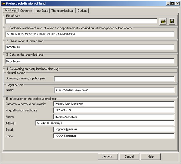
On «Common data» page it is necessary to specify: - Information about the customer of cadastral works - the requisite 4; - Information about the cadastral engineer - the requisite 5. Other requisites 1, 2 and 3 the program will fill automatically, at presence of entered semantics. These data are used at filling the title page. For convenience of repeated data input, all entered information is saved in a file of data (*.MPP).
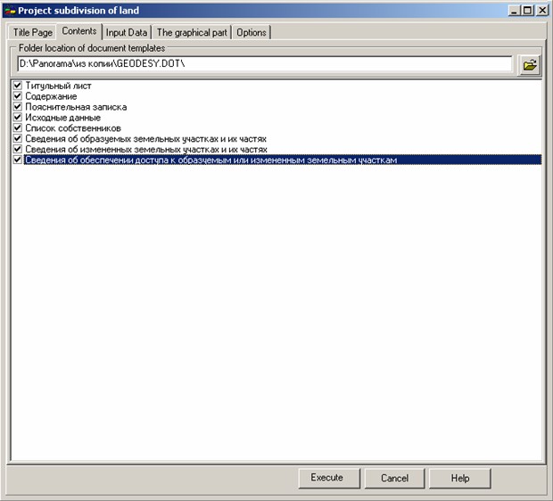
On page «Contents» you specify the structure of the sections included into the technical plan and a folder in which templates of the report are located. The folder of templates specified in options of the «Geodesy editor» is used by default. The structure of standard delivery of the program includes necessary templates for formation of the report. The list of sections names and their corresponding documents templates are described in the file dot.ini. Section [PRJMEJ]. One line corresponds to one section of the report. ATTENTION: do not delete files from folder Geodesy.dot. The list of templates, including their components, is listed in the readme.txt file in folder Geodesy.dot. You can change at any moment structure of sections, only those sections which will be specified on page «Contents», except for the title page and the contents, will be inserted into the report.
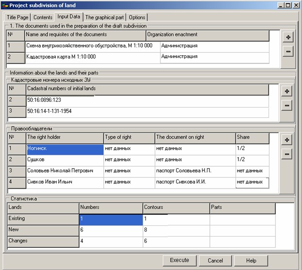
On «Input data» page the information placed into section «Input data» of a survey project is displayed. The information presented in group «List of documents used in the preparation of the draft subdivision» may be obtained by extracting the information on each ground area. The specified data are entered by means of dialogue Editing of REGISTRATION DATA of object (semantics). At absence of data in semantics it is possible to fill the list of documents by hand. The entered data are saved in a file of data. The list of the documents used at preparation of the technical plan, automatically is read out from section [ZEMDOC] of a service file and places into the list for editing. The updated values are used at formation of the report, but not saved into semantics of the ground area (land). The section «Information about the lands and their parts» is formed by the program automatically. The section contains two interconnected tables «Cadastral numbers of initial lands» and «Right holders». For filling the table «Cadastral numbers of initial lands» the program uses data from semantics CADASTRAL NUMBER (therefore, it is important to not delete this semantics at formed lands). The list is formed on the basis of data of all ground areas, thus not repeating cadastral numbers are selected only. For filling the table «Right holders» the program uses semantics corresponding to table positions. The list is formed on the basis of information of all lands, thus all owners of each contour of the land are selected. The list is ordered by the cadastral number. The current status of the table «Right holders» corresponds to current cadastral number in the table «Cadastral numbers of initial lands». At change of a position in the table «Cadastral numbers of initial lands» automatic updating of contents of the table «Right holders» is made. If If necessary in both tables changes can be made. All made changes will be used at formation of the report, but cannot be saved in semantics of objects - contours of the land.
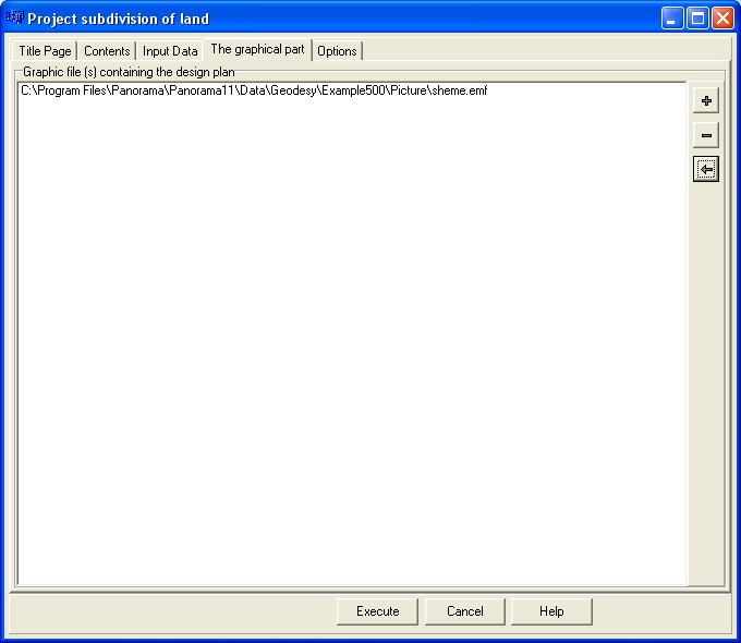
На странице «Графическая часть» указывается состав изображений, используемых при автоматическом заполнении раздела «Проектный план». Для настройки состава графических файлов используйте кнопки
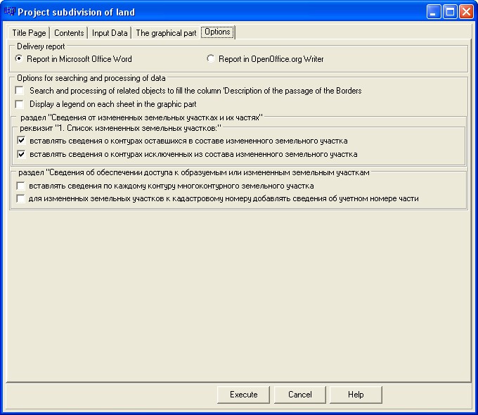
На странице «Параметры» указывается ряд признаков, управляющих автоматизированным процессом заполнения отчета. Названия параметров точно передают информацию о выполняемых программой действиях. |