XML-document "Layout of land plot on the cadastral plan of territory" |


|
|
In dialog of the mode the user has the possibility of viewing and editing information placed into the XML-document.
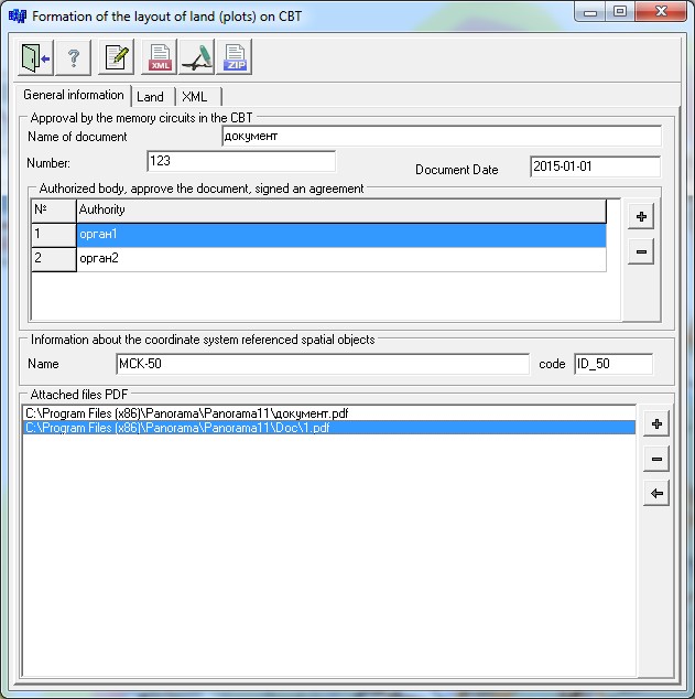
On the page "General information" it is necessary to enter information about the approval of the scheme of the land plot on the cadastral plan of territory, information about the coordinate system referenced by spatial objects, and to specify the attached PDF files. PDF file with image of the textual report the "Layout of the plot on the cadastral plan of territory" in accordance with the requirements of the order of the Ministry of economic development of the Russian Federation from November, 27th, 2014 N 762 "On approval of requirements to preparation of layout of the ground area or the ground areas on the cadastral plan of territory and to a format of the layout of the land plot or land plots on the cadastral plan of territory at preparation of layout of the land plot or land plots on the cadastral plan of territory in the form of an electronic document, form of the layout of the land plot or land plots on the cadastral plan of the territory, preparation of which is carried out in the form of the paper document" can be obtained by means of the mode "Layout area on the cadastral plan of territory".
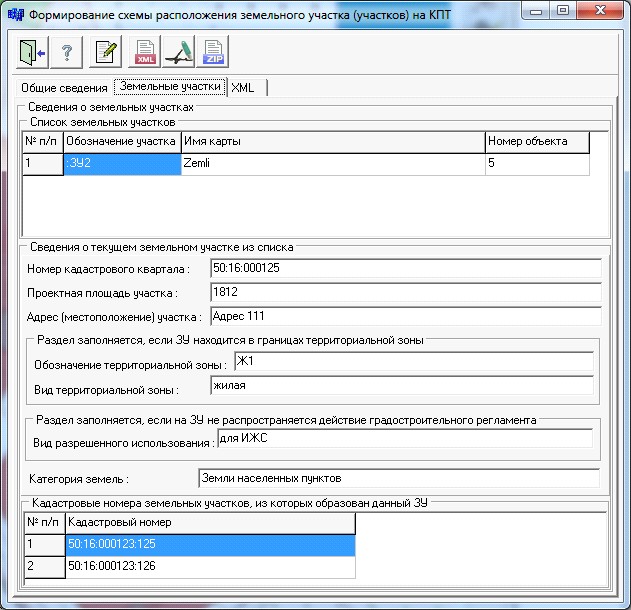
The "Land" page shows the list of the ground areas and data on the current ground area specified in the list. The user is allowed to view and analyze information about the land plots included into the composition of electronic XML-document. To edit information about the current plot of land it is necessary to choose in the list of land the desired line and to press the button On the page "XML" there are specified the unique global identifier GUID, a name and placing of the formed XML-file, information about placing of the XML-scheme of the formed electronic document and a folder in which the archiver necessary for creation of a ZIP-package is located.
The XML-file should conform to scheme SchemaParcels.xsd and be presented in coding Unicode (UTF-8). Version number is 01. The file name should have the following appearance: SchemaParcels_*.xml, where: SchemaParcels - a prefix denoting the belonging the information to the file with information of the Scheme of Land Plot on CBT;
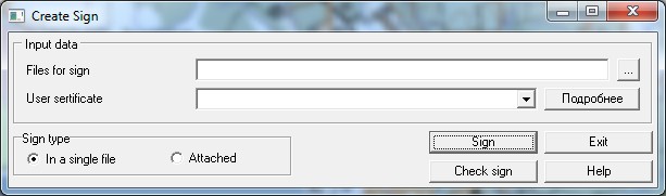
* - unique set of characters, no longer than 50 characters, for example: GUID. For XML-file formation it is necessary to fill all positions of dialog and to press the button The test results are displayed on the page "XML" in the "Verify XML according to the XSD scheme". The most common cause of errors is the absence of data on separate positions. Check up the entered data and make necessary changes. For the formation of the digital signature, click the button
The scheme of layout of the Land Plot (LP) or the land plots on the cadastral plan of territory (further - the Scheme of LP on CBT), prepared in the form of the electronic document, consists of a set of the files packed into one ZIP-archive (hereinafter the package). One Scheme of LP on CBT corresponds to one package. For ZIP-package formation it is necessary to click on the button
The package name must have the following form: SchemaParcels_*.zip, where: SchemaParcels - a prefix denoting the belonging the information to the file with information of the Scheme of Land Plot on CBT; * - an unique set of characters, no longer than 50 characters, for example: GUID. The content of the package is always one XML file that contains semantic information of the Scheme of Land Plot on CBT, and one or more files with the file extension PDF, in full color mode with a resolution of 300 dpi that contains the graphical part of the Scheme of Land Plot on CBT.
XML file and the PDF file must be in the same root directory. The names of the directories and file names must not contain special characters such as: + / \* <>@ «” `] [{} $ # ~.
The recommended operation procedure: - To put onto the cadastral map the land plot (plots), details of which must be present in the scheme. - To create PDF file with image of the text report. - To call the mode by one of the available ways. - To enter the required data in the dialog and to form XML-document. - To create a ZIP-package, having included into it the XML-file and attached PDF-files. |