Parameters of the report |


|
|
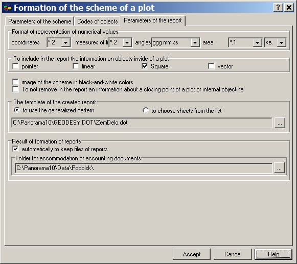
On page Parameters of the report it is specified by what pattern to form the reportand a format of numerical values. The format of representation of coordinates in the report regulates quantity of signs after a comma and number of the signs up to a comma (from a decimal point to the left). Use this property for reduction of meaning positions and unloading of the report. The format of representation of measures of lines defines only number of signs after a comma. The format of representation of angles allows to deduce the information into the report in following variants: dd mm ss.ss - degrees, minutes, seconds, the 100-th shares of seconds; dd mm ss.s - degrees, minutes, seconds, the tenth shares of seconds; dd mm ss - degrees, minutes, seconds; dd mm.mm - degrees, minutes, the 100-th shares of minutes; dd mm.m - degrees, minutes, the tenth shares of minutes; dd mm - degrees, minutes; dd.dddd - degrees, shares of degrees.
All formats of numerical values simultaneously install a format of filling of fields in the report and a format of an output of corresponding titles on the scheme. However in the report there is an additional opportunity for management of a format of coordinates, measures of lines, the areas and angles (Regulated key field in a pattern of reports ). By default the image of the scheme placed into the report, is formed according to the color palette of objects installed in the digital classifier of a map that is how the map looks in a printer view. If it is necessary to make figure of the scheme black-and-white -specify a flag «image of the scheme in black-and-white colors» . If to specify a flag «To create outlines of rotary points of a plot» in the corresponding table of the report where the key field #OUTLINE# is specified, fragments of the image of the scheme in area of rotary points will be inserted. In that case if it is necessary to include into the report the information on internal objects of a plot (constructions, a zones of restriction and so forth) it is necessary to execute the following options: - to set on a map that structure of display, which are desirable for having on the scheme; - to set on page «Parameters of the scheme» thenecessary structure of objects; - on page «Parameters of the report» in group «To include in the report the information on objects inside of a plot» to specify objects of which type to place into the report. If any type will not be specified the information will not be formed. For example, into the report it is necessary to place the information on rotary points of a plot and angular points of the structures located on this plot. It is necessary: - to set structure of display of layers and objects of a map so that such polygon objects as GARDENS, KITCHEN GARDENS, etc., were not visible, i.e. to leave visible only the plots and buildings; - on page «Parameters of the scheme of a plot» to specify structure of objects - «Borders of a plot and a building»; - on page «Parameters of the report» in group «To include in the report the information on objects inside of a plot» to set a flag "polygon". Thus, the program will automatically form heading of the coordinate description by semantics «name» or, at its absence, by the name of object. For example, on a site there are the following objects (see tab.):
п/п the Name of object Semantics "Name " Headings in the report
1 Building, fireproof residential House House
2 Building, unresidential Shed Shed
3 Building of light type Building of light type
4 Kitchen garden Kitchen garden
5 Fruit gardens Fruit gardens
In the event that only the plot must be put on the scheme the installation of flags in group «To include in the report the information on objects inside of a plot» is ignored. Formation of the report can be executed on the basis of two variants of patterns: a separate pattern for each sheet and the generalized pattern. In the first case for each accounting sheet its own pattern is stipulated. In the second case all necessary sheets are included into one pattern. The corresponding group is intended for a choice of a variant of formation of the report. Except for the indication of a variant of formation of the report, there is an opportunity of a choice of a folder, in which patterns (by the first variant) or a name of a pattern (by the second variant) are located. At formation of the report with a choice of documents from the list the program uses in advance prepared lists which are stored in a file dot.ini, located in the same folder, as patterns. Some lists of the patterns, corresponding to a specific target are stipulated: - patterns for a mode «Formation of surveying affair»; - patterns for a mode «Formation of the description of the ground areas»; - patterns for a mode «Equalizing of a theodolitic course (with the scheme)»; - patterns for a mode «Solution of return geodetic tasks»; - patterns for a mode «Solution of direct geodetic tasks»; - patterns for a mode "Tacheometry"; - patterns for a mode «Settings works».
|