Cursor |


|
|
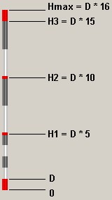
For a visual estimation of relative height of terrain objects ( buildings, trees, etc.) the special cursor-scale is used. At moving the mouse on a surface of three-dimensional model the bottom point of the cursor is set on a surface.
Bottom panel contains the division value (D) which corresponds to height of the bottom part of red color. Short segments of white and grey color are equal to the division value. Red marks in the middle of the cursor correspond to heights: H1 = D*5, H2 = D*10, H3 = D*15. On a map of scale 1:2000 the division value is usually 2 meters, H1 = 10, H2 = 20, H3 = 30 (meters). The bottom panel contains a record: D=2 [10-20-30] m. Option the Big cursor increases the usual cursor-scale into 2 times. |