Advanced parameters |


|
|
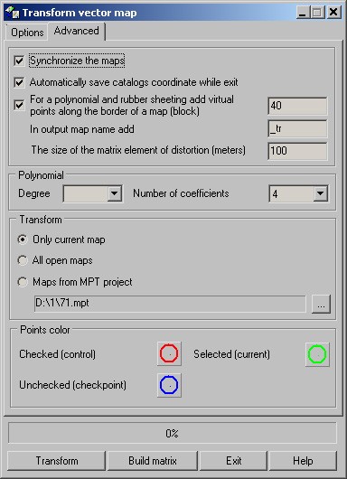
If transformation parameters are calculated, the measured maps synchronously move when you activate the mode «Synchronize the maps». If enabled the mode «Automatically save catalogs of coordinates while exit» the catalogs of coordinates automatically are saved at dialogue closing, or at change of a current map in the mode of transformation only a current map. Addition of virtual points for nonlinear types of transformation is set in the field «For a polynomial and rubber sheeting add virtual points along the border of a map (block)». The name of the output map is automatically formed at change of an input map. By default the output map is located in the Vectrans subdirectory concerning the location of the input map. To a name of the input map there is added a suffix entered in the field «In output map name add». The element's size of a created matrix of nonlinear distortions is set in the input field «The size of the matrix element of distortion (meters)». In group "Polynomial" there is defined the number of coefficients of the polynomial used at a choice of type of transformation «Polynomial (manual setting)». Number of coefficients can be determined, having chosen the degree of the polynomial (from 2 to 5), or by specifying directly the number of coefficients in the appropriate list (from 4 to 21). In group "Transform" the mode of single or stream processing of maps is set. If the mode is used to transform «Only a current map» it is considered that input maps are not bound to each other. In this case the current map is measured and transformed and at change of a current map the measurements begin at first. If the mode is used to transform «All open maps», it is considered that all input maps are in one coordinate system. In this case points are measured at once on all maps, and then all maps are together transformed. If the mode is used to transform «Maps from MPT project» it is assumed that maps in the specified project are in one system of coordinates with a current input map. By pressing button Transform, all vector maps from the specified project will be transformed.
|