Creation of scheme of the document |


|
|
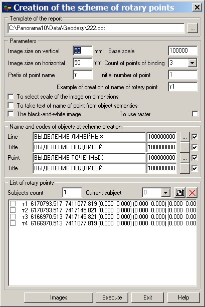
Formation of the scheme of object dialogue is intended for installation of the parameters of two types of the schemes placed into accounting land-management documents: the scheme for surveying affair and the scheme for the description of the ground area. The general technique of installation of parameters for created scheme is identical to both variants, however at formation of the scheme for the ground area the additional initial information defining position of a site on an on duty cadastral map is used. Dialogue contains four pages for input of parameters of formation: Structure of pages of dialogue is defined by type of initial mode which initialized a call. Only those modes which are intended for formation of the description of land-management affair, give a command to dialogue to display "description of ground area" page. After an installation of all parameters of formation press Accept button. If the flag « To create outlines of rotary points of a plot» is set then before formation of the scheme the dialogue " Formation of outlines of rotary points" will appear.
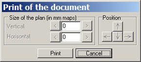
In the event that formation must be done with a choice of documents from the list, dialogue for installation of necessary structure of accounting sheets will be offered. Depending on the chosen mode the program gives an opportunity of a choice of the list of sheets from the fixed set (land surveying, description of the ground area, a return geodetic task). The structure of sheets for each set is described in a file dot.ini. After installation of the necessary list press C ontinue button. On the screen there will be the formed scheme limited by a rectangular dimensional framework. The framework shows what part of the scheme will be placed into the report. Simultaneously on the screen the dialogue " Print of the document" appears.
If necessary to change position of area shown in the report use buttons from Position group. For changing the sizes of printed area use elements from Size of the plan group. For editing the scheme of a plot (change of a location, structure and registration of the scheme) use standard functions of the map editor. At editing it is possible to make any corrections, more often it is required to add or change the location of titles, to make additional registration. It is not expedient to edit the metrics of a plot as the report also there will be changes. In that case if into the report the information on internal objects is placed, it is not desirable also to edit their metrics. When all necessary changes are made, press the Print button.
|