Import from ARINC format |


|
|
This task is intended for import of aeronautical information in format ARINC-424 onto aeronautical maps. Mapping the information is carried out without deleting or modifying the existing objects of a map. The task is started from the menu "File\Import navigation from ... ARINC-424 files".
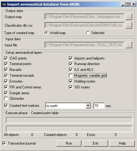
In the field the "Input data" the file in format ARINC is selected by the button "…". After a file choice, its scanning and a structure determination is carried out. Depending on the composition the respective flags become available in the field of "Setup aeronautical layers". In the "Output data" there are selected the "Output map" field and the aeronautical classifier by the buttons "…". If at starting the task there is no open map the fields will be empty. The operator should specify the updated map and the classifier. At choice of a map the information will be complemented. If the map file does not exist, it is proposed to create a map using the standard dialog of filling the passport. Aeronautical map should have the classifier dfc.rsc. Maps with other classifiers can not be processed. "Setup aeronautical layers" field is filled by flags of choosing a category and a subcategory of imported objects. Depending on presence of sections in input file ARINC the appropriate flags will be active.
Flag "Created text markers" is active always and it is intended for forming the titles of points ICAO, terminal points, all categories of navaids and airdromes. Text markers are created in one of nine positions concerning an insert point. One position is at the point of insertion, and eight - are moved in all directions to a distance specified in the adjacent field in millimeters on paper. In the field "Execute phase" in the top line the total process of the import processing is displayed. The percent indicates how much of the objects categories from total number of the chosen categories is processed. Current processed category of objects is displayed in the field "Execute phase". For example, at import of Enroutes, the text will become "Execute phase: Import of Enroutes". The bottom status-line in the field "Execute phase" displays percent of the processed objects in a current category. Under the line the total number of objects for a category, number of the created objects and number of objects with errors are displayed. The list of errors is stored in the log which is a text file. The journal is located in the LOG folder with a map, and has extension «.arinc.LOG». The name of the journal file corresponds to the name of file ARINC from which the import is carried out. The error log contains the date of the starting the operation of import, the full list of errors with indicating the number of line, text content and value. Some errors of import are automatically corrected, for example, magnetic courses of segments which differ less than on 160 degrees.In order to identify an object on the map with the records in the file ARINC and with the line number in which there was an error, objects on a map are added by semantics 32900 «ID in a database». ID value corresponds to the line number.
Singularity of import converter work: Specification of sections ER, EP of format ARINC (routes) does not contain coordinates of segments, and stores identifiers of points and navaids between which segments of routes are laid. Process of creating the metrics of routes segments provides for presence of coordinates of segments points. To obtain the metrics of points, the file containing Enroutes should contain sections with points through which these routes are laid. Import of a routing part is accompanied by preliminary loading the table of points. Points should be present at file ARINC in the form of sections EA, PC, DB, D_. At drawing of routes of a point are not plotted. Drawing of points is carried out at choosing flags of the appropriate objects categories.
Checking the import: 1. To choose file UU.arinc.txt in the top part of the form. 2. To open or create a resulting map. It is necessary to make sure that the map is based on the aeronautical classifier dfc.rsc. 3. To choose the necessary sections, having indicated the flags. Only those flags are available, the sections for which are in file ARINC. 4. To press the button "Run". If it is necessary to interrupt process - click the button "Break". 5. In the presence of critical or logic errors, it is possible to see theirs list in the log of import. Import log is a text file with extension "arinc.LOG" in LOG folder.
|