Calculation of projection parameters of local coordinate system |


|
|
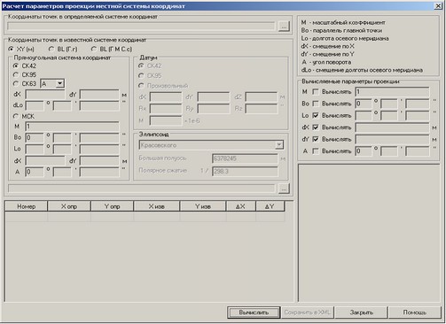
The task is intended for calculation of projection parameters by a set of points coordinates in local and state coordinate system. Results of calculations can be saved in XML file for their subsequent use at creation of digital maps.
The initial data for calculations are the coordinates of points in local (X, Y) and geodetic coordinate system (latitude, longitude). Geodetic coordinates can be loaded from the catalogue of coordinates or be calculated by coordinates in state (CS42, CS63, CS95) or local coordinate system with known parameters. It is necessary to notice that the known coordinate system should be oriented in the same way as the defined one. That is, they should have the same spheroid and Datum. It is possible to calculate any parameter of projection Transverse Mercator, a subset which is the widespread domestic projection of Gauss-Kruger (scale factor = 1, a parallel of the main point = 0). In addition to these parametres the turn angle can be calculated which is often used in domestic local coordinate systems. For a choice of the calculated parametre it is necessary to enable the mode Calculate to the right of the parameter name. If you know the approximate value of the calculated parameter, you can enter it. In this case the entered value will be used as the approximation in the first iteration of clarification. It can improve convergence of process of parameters clarification. It is especially important to specify approximate value of the longitude of central meridian. Values of noncalculated parameters should be necessarily entered manually. Calculations are performed by successive approximations. On each iteration the corrections are calculated in values of unknown calculated in the previous iteration. The cycle ends when the corrections values become less than tolerance. If during 100 iterations a limit is not reached, the last values of calculated parameters are returned. With use of calculated parametres there are defined the residual divergences on points which are shown in the table. By residual divergences the mean-square deviation (MSD) is calculated for the analysis of accuracy of the received results. MSD is calculated separately for the control and check points. Control points are used at calculation of parameters. Control points are the points with a check mark in point number. Checkpoints with the switched off check mark in number are not used in calculations. MSD by control points enables independent estimation of calculations accuracy. In calculations there is not used the Datum - parameters of transition from the chosen spheroid onto spheroid WGS84. But this data are needed for a complete description of the coordinate system at saving in XML. Therefore into dialogue the field a Datum is added, allowing to enter the necessary values.
Sequence of processing
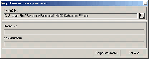
Preliminarily it is necessary to prepare two catalogues of coordinates. In the catalog of defined coordinate system line-by-line the coordinates of points in local coordinate system should be written down in the format of Point_number Hm Ym. In the catalogue of known coordinate system there should be written down the geodetic coordinates (Point_number Latitude Longitude) of the same points or plane coordinates (Point_number Xm. Ym.) in the coordinate system that permits the recalculation into geodetic coordinate system (CS42, CS63, CS95, local coordinate system with known parametres). Geodetic coordinates can be entered in degree fractions (Point_number DD.dd DD.dd) or in degrees, minutes, seconds separated by a space (Point_number DD MM SS.ss DD MM SS.ss). Sequence of points in the catalog does not matter. At loading the points are automatically sorted by numbers. Instead of number it is possible to use any text without spaces. Catalogues of defined and known coordinate systems are loaded by pressing the button … in the appropriate field. Before loading points in known coordinate system it is necessary to choose a format of coordinates catalog (XY (m.), BL (BL (D M S.s). The loaded points are displayed in the table. By default to all of them the control point sign is assigned (the check mark in point number is put). If plane coordinates of points (Х, Y) are loaded, then it is necessary to specify type of coordinate system to define parameters of recalculation into geodetic coordinates system. In this case in group Cartesian coordinate system it is necessary to choose type of known coordinate system and if necessary to specify its parameters. For CS42, CS95, CSК63 it is not necessary to specify number of zone, it will be defined by the first character in Y of the first point in the catalogue of coordinates. For CS63 it is necessary to set the region identifier (A-Z). For local coordinate system (LCS) on the basis of CS63 also it is necessary to specify shift in the plan concerning the centre of zone and if so, the shift of the central meridian of LCS relative axial meridian of the corresponding zone of the specified region. For a binding to LCS, which parametres are known or earlier were calculated, it is necessary to enter all parameters of projection Transverse Mercator. Further it is necessary to choose Datum and spheroid. For CS42, CS95, CS63 there are used standard Datum and spheroid. For LCS it is possible to specify any Datum and spheroid. If points in geodetic coordinate system are loaded, then group the Cartesian coordinate system is unavailable. In this case it is necessary to choose only Datum and spheroid (in Russia the Krasovsky's spheroid practically is always used). Next you need to specify which parameters should be calculated, having put the check mark to the right of the parameter name. Usually LCS are based on the state coordinate system, using the projection of Gauss-Kruger. Therefore it is not necessary to calculate the Scale factor M and Origin latitude Bo (M = 1, Bo = 0). Turn angle A seldom is not equal 0. If at inclusion of calculation of the turn angle considerably MSD is reduced, then the turn of local coordinate system really is present. Origin longitude Lo, shift on Х and Y (dX, dY) it is necessary to calculate. If you see that the calculated origin longitude is almost equal to the whole degrees, it is possible to enter this value and to disable the calculation of Lo. By this mode it is possible to raise accuracy of calculation of dX, dY. In general, for accuracy increase it is necessary to aspire to decreasing the number of calculated parameters. That is, if the parameter value is known, it it is necessary to enter it and disable calculation. Calculation of parameters is carried out by pressing the Calculate button. If calculation has ended successfully, then there will be shown the number of iterations, the calculated values and MSD for control and check points. If at calculation there was an error, then in measurements there are blunders, or parameters of known coordinate system are incorrectly entered. For search of errors in coordinates it is necessary to leave included three most distant points reliable. If by them the parameters are calculated, then other points need to be added by one, recalculating parametres after point addition. After calculation the parameters can be saved in XML for their subsequent use in the GIS Panorama at creation of digital maps. By pressing the Save to XML button the dialog is called Add reference system.
By default the new reference system is created in preinstalled in the GIS Panorama list of “LCS of Subjects RF.xml”. It is possible to change a list file, having pressed the button to the right of the field File XML and having chosen it in standard dialog of opening a file. If to enter a new name in dialog of a file choice the new list will be created. For identification of the reference system it is necessary to enter the name and an optional comment. After pressing the Save to XML button the reference system is stored in the chosen list and the dialog is closed. |