Import of raster from the formats IMG, Tiff (GeoTiff), JPEG... |


|
|
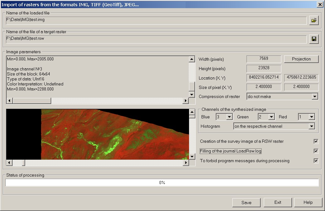
The mode is intended for loading raster data of formats IMG, Tiff (GeoTiff), JPEG and others into a raster map RSW. Launch of the mode "Loading raster data of formats IMG, Tiff (GeoTiff), JPEG» is made from dialog "Run Application".
If the data type of the channel differs from value Byte, it is recommended to apply the mode «Histogram» in group «Channels of the synthesized image». Dialog allows to customize channels of the synthesized image for saving into a raster map RSW. In group «Channels of the synthesized image» specify conformity of channels numbers for each component of color. Use the mode «Histogram» if the data type of the channel has one of values: UInt16, Int16, UInt32, Int32. The image of a raster map is displayed in a window of dialog with the specified options. The program defines a geospatial placing the image by data from corresponding tags of files GeoTIFF, IMG. Also the program carries out search and the analysis of files of placing the image. As the files of placing, the following formats of files are processed: TAB, world file
Procedure to save image in RSW file: 1.Select the source file of the raster image. 2.Specify a name of saved file *.RSW. 3.Customize channels of the synthesized image for saving into a raster map RSW. 4.Click "Save" button. 5.Open the generated file in a new window of the program (File-> Open-> Raster maps (RSW)).
Procedure to save the image in TIFF file: 1.Select the source file of the raster image. 2.Specify a name of saved file *.TIF. 3.Click "Save" button. 4.Load the file *.TIF by standard means of the program (File-> Open-> Raster maps (RSW, TIFF, BMP)). If the source file is a multispectral it is necessary to put a tick «Do not copy the source image into RSW file» in dialogue Loading of files of graphic formats into a raster map.
Auxiliary options: Projection button is intended to call the dialog «Parameters of a raster projection». In the dialog the parametres of a projection and system of coordinates which will be written down into the formed file of a raster map are specified. The mode allows to see result of the analysis of the data about parametres of a projection and coordinate system of the initial image. Compression of raster RSW - a mode of compression of output raster RSW. For obtaining the compressed raster RSW specify from the drop-down list the used method of compression to the image of output file RSW. Following methods of compression can be used: LZW, JPEG. The method of compression JPEG is applied only for rasters with color depth of 24 bits per pixel. Creation of the survey image of a RSW raster - the mode is intended for connection of function of creating the survey image of raster RSW after converting the image. Mechanism of substitution of the raster's image by its reduced copy is applied to increase the speed of displaying a raster map at map scaling. Now two levels of the reduced copy of the raster's image are supported. Filling of the journal LoadRsw.log - the mode is intended for connection of function of conducting the transaction log during converting the image of a raster. At the included mode «Filling of the journal LoadRsw.log», the file LoadRsw.log is created in a folder of output raster. To forbid program messages during processing. At converting the image of a raster the program can output diagnostic messages. For example: «An error of removal of an existing file. Probably, this file is already used.», «The requested parameters of the image are incorrect.», «Error of request of the channel of the image.», etc. To forbid delivery of messages of the program check the box "To forbid program messages during processing". At enabling this mode it is recommended to use the mode «Filling of the journal LoadRsw.log». Mode Import of raster from the formats IMG, Tiff (GeoTiff) uses functions of open library for work with the raster and vector data, databases and web-services - GDAL/OGR 1.9.0
|