Import of geodetic measurements |


|
|
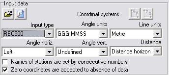
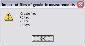
Procedure is intended for an execution of import of digital data's files received in field conditions by means of geodetic devices, equipped by resources of electronic processing. This program's version allows to process input data in formats: - RAW; - SDR (33, 20); - GTS (6, 600, 700); - DC1 (PENTAX); - M5; - R5; - R4; - GPT; - GRE; - GSI; - IDX; - REC500; - 3TA5; - 4TA5. The dialog window logically is divided onto four parts. In the left top part the information and the elements of management concerning input data are displayed. In the right top part the information and the elements of management concerning formed result of processing of input data are displayed. In the left bottom part the block diagram of a current course is displayed In the right bottom part the figure of a course with directions onto picket points is displayed. During opening an input file its format is automatically defined. After opening a file its data and parameters are displayed in Input data window further processing of a file is made. During converting the input file will be transformed to three files: a file of theodolitic courses (.TEO format) and a file «POLAR», containing data for the decision of a direct geodetic task (.TPR format) and (at presence in input file of coordinates of points) a file of the list of coordinates (.XYH format). Data of an output file (.TEO, TPR, XYH) are displayed in Output data window depending on what "switch" is exposed). Names of output files, if necessary, can be changed by pressing the corresponding button to the right of a line with a file name. During one session it is possible to make converting of several files (the dialog window is closed after pressing the Save button). If coordinates of control points in an input file (or in extra loaded catalogue) are presented in the right system of coordinates (X - to the right, Y - upwards), it is necessary to include the corresponding button in Input data window. By default zero coordinates are accepted as absence of data, in the switch the tick is exposed. For format REC 500 the opportunity of its editing is stipulated, if numbers of stations are set by consecutive numbers, for this purpose in the switch the tick is exposed.
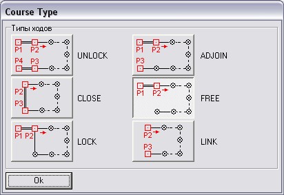
The type of data presentation in an input file (a format of representation and type of angles) is defined automatically, however, if automatic definition is made incorrectly, the user can specify correct values. So if in format REC 500 the measurements were made in degrees it is necessary to choose a corresponding measure of angles. The type of a current course "FREE» (with coordinate binding) is defined automatically. Following types of courses are possible: - unlock (classical); - lock; - close; - adjoin; - free (hanging); - link (with a coordinate binding). In detail classification of types of courses and description of structure of output data are shown in the document: Structure of files of geodetic measurements (GeoBin.doc).
If in an initial file there are some courses then for reception of correct result the user should specify type of a course for each course or leave the type of a current course by default. For receiving the correct result the user should specify type of a course (for everyone, if there are some of them in an input file).
The type of data presentation in an input file (a format of representation and type of angles) is defined automatically, however, if automatic definition is made incorrectly, the user can specify correct values. So if in format REC 500 the measurements were made in degrees it is necessary to choose a corresponding measure of angles. In Reference points window it is possible to carry out a choice of a reference point, as a result the scheme of a course is reconstructed. Here it is possible to enter coordinates of reference points, then to press button "Recalculation" which is in the right bottom part of a window. By pressing of the button "Execute" there is a message in which it is informed on what files are created.
For receiving the correct result it is necessary, that during field works the following requirements were carried out: 1. All points (stations and pickets) should have unique not repeating numbers (names). 2. Different points (including the belonged to different courses) should have different names. 3. The first observation from the first and the last station of a course should be «linked». If from first or last point of a course some observations are made, at first the control point and then the pickets must be observed. At intermediate stations it is supposed to carry out observation in the any order. 4. It is recommended to save the information on one course into one file.
|