Add Map Insert |


|
|
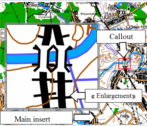
Insert can be created as a standalone element of decor. In this case after activating the mode, drawing of a rectangle for insert (by two points) and a choice of a map file for insert are carried out. Besides, insert can be created as an addition («enlargement») to already existing insert. For example, for the main map - insert which is the main background of the document, it is necessary to put some additional inserts, displaying in the enlarged scale the sections of the main insert.
To create an «Enlargement», after activating the mode, press the «S» key (or press the right mouse button and select the appropriate mode), select the object on the map - the main inset, and execute drawing of a rectangle for the inset (at two points). In this case, the selection of the file - a map for insertion is not performed. The link to the file, the current scale and positioning of the insert are automatically copied from the main insert. After rectangle drawing by its contour, two objects are created: new insert («Enlargement») with the image identical to the main insert and an additional object - Callout. Callout is a contour rectangle that displays the position of «Enlargement» on the territory of the main «parental» insert. When editing the «Enlargement» using the «Edit Insert» mode (change of positioning and scaling of the map), the position and sizes of the Callout change automatically. If editing the «Enlargement» was carried out using the tools of Map Editor, you should activate the «Edit Insert» mode and update the callout image, for example, by sequential scaling +, - or by a slight movement of the map.
|
 Insertion of maps is performed as part of pre-formed map projects (MPT). Map projects are formed by means of GIS Panorama tools. Vector and raster maps, DEMs, external geoportals, as well as data located on GIS servers can be included in the map project.