Count of geodesic coordinates |


|
|
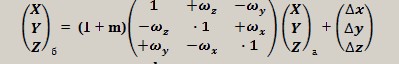
Count of geodesic coordinates task allows to execute recalculation of coordinates of map objects, using seven elements of transformation. The general view of the formula for an execution of transformation looks like:
The task can be applied to transition from the standard systems of coordinates (CS95, CS42, WGS84/UTM, etc.) to local systems of coordinates (LCS) and back according to the Governmental order of the Russian Federation from 3.03.2007 N 139. The local system of coordinates is understood as the conditional system of the coordinates, established concerning limited territory, not exceeding territory of the subject of the Russian Federation, whose zero of coordinate system and orientation axes of coordinates, are displaced in relation to zero of coordinate system and the orientation of axes of coordinates of uniform state system of coordinates used at realization of geodetic and cartographical works (further - the state system of coordinates). Local systems of coordinates are established for realization of geodetic and topographical works at engineering researches, construction and maintenance of buildings and constructions, a surveying of the grounds, conducting of cadastres and realization of other special works. The obligatory requirement at an establishment of local systems of coordinates is the possibility of transition from local system of coordinates to the state system of coordinates which is carried out with use of parameters of transition (keys). For an example we shall consider a task of transformation of a map onto territory of Leningrad region supporting geodetic system of coordinates, to local system of coordinates. Let's choose for construction of local system of coordinates the following parameters: - ellipsoid WGS-84; - projection UTM, a zone 36; - system of heights Baltic's 1977 year (recalculation of height for local CS is not carried out); - displacement to the beginning of local CS relatively of CS WGS84: DХ =-23.400 m; DУ = 117.400 m; DZ = 73.650 m; - angles of turn of axes of local CS relatively of CS WGS84: WX = 0.135"; WY = 0.345"; WZ = 0.815"; - scale factor (M = 0.05 mm/km = 0.05*10e-6). For transition from geodetic system of coordinates (CS95, CS42, WGS84/UTM, etc.) to local CS by the specified parameters it is necessary to execute the following actions: - to recount coordinates of map's objects from system of coordinates of a map (for example, CS95 or CS42) onto ellipsoid WGS-84; - to recount geodetic coordinates by 7 factors; - to recount the received geodetic coordinates into the chosen projection (for example, WGS84/UTM, zone 36); - to make changes into the passport of a map (to replace a type of a map - topographical WGS84/UTM onto Large-scale plan). As a result we receive a map in local system of coordinates. Keys are the following parameters - 7 factors for recalculation of coordinates, a type of an ellipsoid on which recalculation of coordinates by factors is executed, a kind and parameters of a projection in which flat rectangular coordinates are counted (in an example - WGS84/UTM, zone 36). The knowledge of the given keys allows to execute if necessary the return recalculation of a map from local system of coordinates to the source geodetic system. The described above recalculation to local CS or back for a map consisting of any number of sheets and objects, is carried out in an automatic mode by means of the task: Count of geodesic coordinates. The sequence of actions of the user for described above an example can have a following appearance.
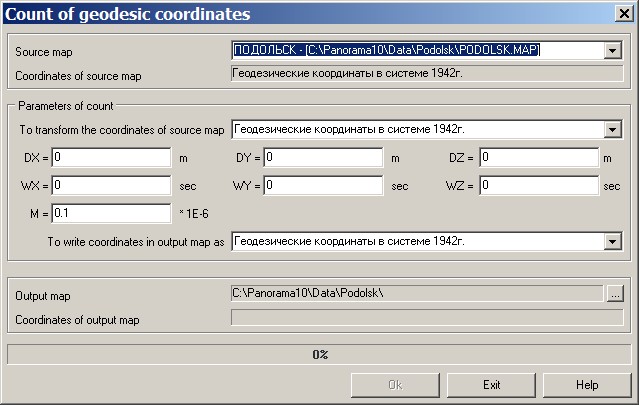
1. We shall prepare a template of an output map. For this purpose we shall create the user map (File - New - User map) with parameters: - Map file - to enter a demanded name of a file of the map passport in a separate folder; - Resource file (RSC) - to specify RSC of the source map; - Name - to specify the name of source area or a new one; - Map type - UTM WGS 84; - Picture base scale - to specify scale of a source map; - Zone number - 36 (it is possible to specify an axial meridian - 33 or other value for complication of parameters of transition). Let's execute creation of a map with opening in a new window (option: Open new document). The same operation can be executed and from dialogue of the task: Count of geodetic coordinates if to specify as an output map a new file. 2. To start onto an execution the task: Count of geodetic coordinates. To enter parameters of transition: - in a field "To transform coordinates of source map" to choose Geodetic coordinates in WGS-84 system; - in a field "Output map" to choose a name of preliminary created user map (SIT); - in a field "To write coordinates in output map as" to choose Geodetic coordinates in WGS-84 system; - displacement to the beginning of local CS (DХ =-23.400 m; DУ = 117.400 m; DZ = 73.650); - angles of turn of axes (WX = 0.135"; WY = 0.345"; WZ = 0.815"); - scale factor (M = 0.05 mm/km = 0.05*10e-6).
To press Ok button. After completion of the task to close dialogue and to close a source map. The output map will be automatically opened. 3. To make changes into the passport of an output map. To open the passport of a new map (Tools - View Passport). To set type of an electronic map - Large scale plan, and to save the passport of a map. Thus all parameters of a map projection will be reset - the map will be translated into local coordinates system (CS).
For an execution of a return task of transition from local CS to the initial geodetic system of coordinates it is necessary to execute the following actions: 1. To make changes into the passport of a map in local CS. To open the passport of a new map (Tools - View Passport). In "Projection \ Projection parameters" bookmark - to specify Zone number 36 (or the central meridian which has been entered at creation of a map) and to press Enter. To save the passport of a map. 2. To start onto an execution the task: Count of geodetic coordinates. To enter parameters of transition: - in a field "To transform coordinates of source map" to choose Geodetic coordinates in WGS-84 system; - in a field "Output map" to choose a name of preliminary created user map (SIT) with parameters of the source system of coordinates (CS95, CS42, etc.); - in a field "To write coordinates in output map as" to choose Geodetic coordinates in WGS-84 system; - displacement to the beginning of local CS to enter with an inverse sign (DХ = +23.400 m; DУ =-117.400 m; DZ =-73.650); - angles of turn of axes to enter with an inverse sign (WX =-0.135 "; WY =-0.345 "; WZ =- 0.815 "); - scale factor to enter with an inverse sign (M =-0.05 mm/km =-0.05*10e-6). To press Ok button. After completion of the task to close dialogue and to close the source map. The output map will be automatically opened. Coordinates of objects should be restored to the source coordinates. At transition from CS95 to the local CS, based on WGS 84, and back the error usually is of the order of several centimeters in the plan.
|